The San Diego Maritime
Museum
The Star of India
San Diego, CA
January 3rd, 2003
As 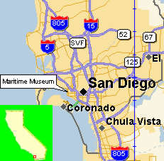 we wound down our trip through California,
we settled into San Diego county for several weeks. This is a tremendously
vast land area, and much time was needed to see as much of it we could.
Our first outing was into the city to find the San Diego Maritime Museum and its
pride and joy, the "Star of India". The "Star of India",
is a magnificent sailing ship, actually it is a three masted barque. It
is the oldest iron-hulled merchant ship afloat. Built on the isle of man, in
Great Britain. The ship was launched in 1863 and christened "Euterpe".
The trans-Pacific trade from 1871-1898 resulted in the Euterpe
circumnavigating the earth twenty-one times and stopping in San Francisco in 1873
and 1883. She was purchased by the Alaska packers association to service
the salmon canneries in Alaska, leaving each season from Alameda. During
we wound down our trip through California,
we settled into San Diego county for several weeks. This is a tremendously
vast land area, and much time was needed to see as much of it we could.
Our first outing was into the city to find the San Diego Maritime Museum and its
pride and joy, the "Star of India". The "Star of India",
is a magnificent sailing ship, actually it is a three masted barque. It
is the oldest iron-hulled merchant ship afloat. Built on the isle of man, in
Great Britain. The ship was launched in 1863 and christened "Euterpe".
The trans-Pacific trade from 1871-1898 resulted in the Euterpe
circumnavigating the earth twenty-one times and stopping in San Francisco in 1873
and 1883. She was purchased by the Alaska packers association to service
the salmon canneries in Alaska, leaving each season from Alameda. During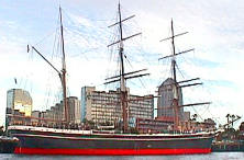 1902-1923 "Euterpe" was renamed "Star of India". She
continued to sail the Pacific Ocean as an active reminder of the early
California's marine commerce. A barque closely resembles a full-rigged ship but the aftermost mast
carries a fore and aft rig instead of cross yards. This rig trades sail area and power for smaller crew requirements and greater maneuverability.
The worst characteristics of all of the great "square riggers" was
that they could only sail downwind.
1902-1923 "Euterpe" was renamed "Star of India". She
continued to sail the Pacific Ocean as an active reminder of the early
California's marine commerce. A barque closely resembles a full-rigged ship but the aftermost mast
carries a fore and aft rig instead of cross yards. This rig trades sail area and power for smaller crew requirements and greater maneuverability.
The worst characteristics of all of the great "square riggers" was
that they could only sail downwind. 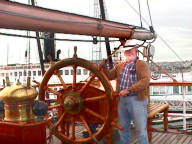 It wasn't until the invention of the Marconi rig that a ship could sail within
45 degrees of the direction that the wind was blowing. Although there was
a party on the deck the Star of India, scheduled later in the evening, we were allowed aboard for a short
visit. I couldn't help but work my way back to the helm and presenting
a stoic poise, manned the wheel. I once took a short ride on a Marconi rigged
tall ship and
It wasn't until the invention of the Marconi rig that a ship could sail within
45 degrees of the direction that the wind was blowing. Although there was
a party on the deck the Star of India, scheduled later in the evening, we were allowed aboard for a short
visit. I couldn't help but work my way back to the helm and presenting
a stoic poise, manned the wheel. I once took a short ride on a Marconi rigged
tall ship and  was given the honor of manning the
helm for a short period of
time. The feeling is unbelievable. It is so heavy and
large that I thought it would be unwieldy but to my surprise it was
a nimble and responsive vessel that was easy to maneuver. The most
marvelous thing about these old square riggers is the complexity of the lines
(ships do not have rope) that are required to maintain the sails in their proper
place. Each line has a specific purpose and a specific name. It was
the responsibility of the deck hands to memorize the proper name for each one of
them. When the officer of the
deck needed to move a particular sail he might call out the name of the lines he
needed manipulated and the deck hands were expected to act snappy in handling
them. Each line has a specific place to be anchored aboard ship. A
loose line was considered a hazard on deck. The below deck area has been turned
into a display area for the tools and memorabilia. Of particular interest
to me was the short
was given the honor of manning the
helm for a short period of
time. The feeling is unbelievable. It is so heavy and
large that I thought it would be unwieldy but to my surprise it was
a nimble and responsive vessel that was easy to maneuver. The most
marvelous thing about these old square riggers is the complexity of the lines
(ships do not have rope) that are required to maintain the sails in their proper
place. Each line has a specific purpose and a specific name. It was
the responsibility of the deck hands to memorize the proper name for each one of
them. When the officer of the
deck needed to move a particular sail he might call out the name of the lines he
needed manipulated and the deck hands were expected to act snappy in handling
them. Each line has a specific place to be anchored aboard ship. A
loose line was considered a hazard on deck. The below deck area has been turned
into a display area for the tools and memorabilia. Of particular interest
to me was the short 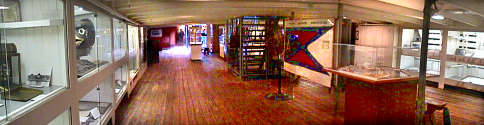 history
on the early days of navigation. We learned that In 1493 Pope
Alexander VI established a line 100 leagues (some 300 nautical
miles) west of the Azores. To the south and west of that line toward India he granted to Spain exclusive right to and possession of all lands not held by a
Christian Prince on Christmas Day. Lands to the east of that line were ceded to
history
on the early days of navigation. We learned that In 1493 Pope
Alexander VI established a line 100 leagues (some 300 nautical
miles) west of the Azores. To the south and west of that line toward India he granted to Spain exclusive right to and possession of all lands not held by a
Christian Prince on Christmas Day. Lands to the east of that line were ceded to 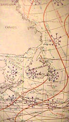 Portugal.
The intent was to end continuous conflicts over possessions being discovered by the two nations.
Later the Pope would add a second line in the Pacific, separating possessions claimed by the same two countries. These
lines of demarcation were the first geo-political borders to be based on the cartographic reference system (Longitude) rather
than geographical features such
as rivers or coastlines. No means for establishing or finding the location of the lines with any accuracy would
exist for another 250 years. In 1698, Captain Halley left England on the Paramore, sailing into the North
Atlantic. He hoped to improve knowledge of the Longitudes with the aid of a
compass. He gathered a tremendous amount a information about currents, distance measurements and directions.
From this he produced the first charts to depict the extent of trade winds and variations of
the Earth's magnetic field as isogones (geographical representations of data of
lines of constants value). Information represented geographically; wind currents, magnetic variations,
prevalence of storms, calms, heavy
Portugal.
The intent was to end continuous conflicts over possessions being discovered by the two nations.
Later the Pope would add a second line in the Pacific, separating possessions claimed by the same two countries. These
lines of demarcation were the first geo-political borders to be based on the cartographic reference system (Longitude) rather
than geographical features such
as rivers or coastlines. No means for establishing or finding the location of the lines with any accuracy would
exist for another 250 years. In 1698, Captain Halley left England on the Paramore, sailing into the North
Atlantic. He hoped to improve knowledge of the Longitudes with the aid of a
compass. He gathered a tremendous amount a information about currents, distance measurements and directions.
From this he produced the first charts to depict the extent of trade winds and variations of
the Earth's magnetic field as isogones (geographical representations of data of
lines of constants value). Information represented geographically; wind currents, magnetic variations,
prevalence of storms, calms, heavy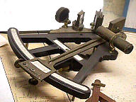 seas, and icebergs. These maps are called
"pilot charts" and are the direct descendants of Halley's isogonic
designs. Navigation is the process of finding your way from one fixed location to another
by learning where you are in between. Early ocean travel relied on visual contact with the shore and
if sailors were blown out to sea they were lost until sighting the coast again. To safely navigate out
of sight of land, mariners would need instruments capable of observing direction, distance traveled, time spent
traveling and ultimately their own precise location. The development of these instruments changed the
world. The sextant, introduced in 1767, was capable of reflecting greater angles
than
was the octant (up to 120 degrees) and could measure vertical and horizontal angles at sea. It has evolved into the ultimate hand held navigational
instrument for taking "star sights" and is still in use today. There
seas, and icebergs. These maps are called
"pilot charts" and are the direct descendants of Halley's isogonic
designs. Navigation is the process of finding your way from one fixed location to another
by learning where you are in between. Early ocean travel relied on visual contact with the shore and
if sailors were blown out to sea they were lost until sighting the coast again. To safely navigate out
of sight of land, mariners would need instruments capable of observing direction, distance traveled, time spent
traveling and ultimately their own precise location. The development of these instruments changed the
world. The sextant, introduced in 1767, was capable of reflecting greater angles
than
was the octant (up to 120 degrees) and could measure vertical and horizontal angles at sea. It has evolved into the ultimate hand held navigational
instrument for taking "star sights" and is still in use today. There
 were
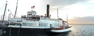
two other ships tied along side the Star of India. The Berkeley is an old Ferry
boat which can be rented for private affairs while serving as a dock for
a delightful small sailing ship. We worked our way down a swinging gangplank and
stepped out onto the deck of the Medea. During the early 1930, Medea served as
Commodore's Vessel at the prestigious Royal Northern Yacht Club, Rhu Scotland. Later she joined the
Pool and Dorset Yacht Club. and cruised off the Isle of Wright. On July 14, 1973, Medea rounded Point Loma and entered San Diego
Bay. flanked by local yachts. She has been a proud part of the the Maritime Museum since that date, and steams around the Bay two days a
month. Medea is one of the last few steam yachts in the world, and a survivor of an era when style and comfort went hand in hand with travel
afloat. It was a nice way to spend an afternoon, and a high point of
interest to old sailing ship buffs.
were
two other ships tied along side the Star of India. The Berkeley is an old Ferry
boat which can be rented for private affairs while serving as a dock for
a delightful small sailing ship. We worked our way down a swinging gangplank and
stepped out onto the deck of the Medea. During the early 1930, Medea served as
Commodore's Vessel at the prestigious Royal Northern Yacht Club, Rhu Scotland. Later she joined the
Pool and Dorset Yacht Club. and cruised off the Isle of Wright. On July 14, 1973, Medea rounded Point Loma and entered San Diego
Bay. flanked by local yachts. She has been a proud part of the the Maritime Museum since that date, and steams around the Bay two days a
month. Medea is one of the last few steam yachts in the world, and a survivor of an era when style and comfort went hand in hand with travel
afloat. It was a nice way to spend an afternoon, and a high point of
interest to old sailing ship buffs.
For more information about this adventure visit their web site at www.sdmaritime.com.
*** THE END ***